


وصف لـ Mobile Topographer GIS
The beloved choice of the professionals, Mobile Topographer ...meets... GIS.
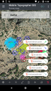
You can now perform a complete survey without any limitations into complexity or volume of data.
Try now Mobile Topographer GIS by using the three days free trial period. Just download the app and proceed with he subscription procedure. Although, you will be asked to provide billing information, you will NOT be charged before the end of the three days of the free trial period. You can cancel your subscription at any time during the three days trial period, free of charge. Charges will only occur, if at the end of the three days you still have an active subscription.
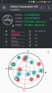
- Collect GNSS readings using increased accuracy (GPS, GLONASS, Galileo, Beidou, QZSS constellations supported).
- Connect your external GNSS receiver via mock locations and use Mobile Topogrpaher GIS as a processing unit.
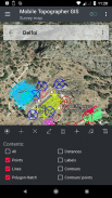
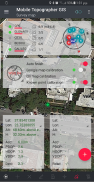
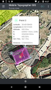
- Display data into WGS84 or you local projected CRS.
- Convert from WGS84 to local projected CRS and vice versa.
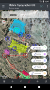
- Real time projection on map.
- *** NEW *** Custom image or WMS server as map background.
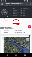
- Find a marked point in the real world by using "Drive me"
- Calculate Orthometric height on the fly using EGM model or local elevation grids where available.
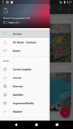
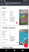
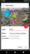
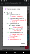
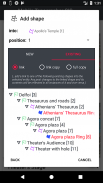
- Organize your work into Points - Shapes - Entities & Surveys. You can now create individual points, multi-point groups, multipart polylines, and multipart polygons with holes.
- Create a full drawing with as much details as you want.
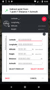
- *** NEW *** geodetic tools. Add indirect points via on of the following options: 1 point + Distance + Azimuth, 2 points + Distances + Select, 2 points + Azimuths, 3 points + Distances, Midpoint of line, Divide line, Extend line, Parallel line, Perpendicular to line.
- Nest your jobs, in any nesting level, to create a super-survey.
- Share data between jobs with active links.
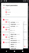
- Exchange jobs between your mobile device and your desktop computer, with import - export functions using all common formats .txt, .csv, .kml, .gpx, .dxf and Shape files (.shp - .shx - .dbf)
- Collaborate with your partners by exchanging and sharing from one point to complete jobs.
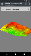
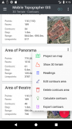
- Create the 3D terrain of an area by simply walking through it.
- Calculate contours and add them into your survey with lightning speeds.
- View a real 3D model directly into your device.
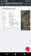
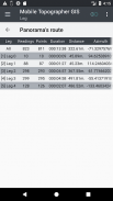
- Store a route with its data.
- Show GNSS satellites with signal info in both compass view or AR.
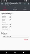
- Backup and restore your data using an SQL .db file.
Welcome to the era of mobile surveying...!
Find more about Mobile Topographer GIS in:
http://applicality.com/projects/mobile-topographer-gis/
Download the user's manual from:
http://applicality.com/app_documentation/web/MobileTopographerGIS_Manual.pdf
اختيار الحبيب من المهنيين، موبايل الطوبوغرافي ... يلتقي ... GIS .
يمكنك الآن إجراء مسح كامل دون أي قيود في تعقيد أو حجم البيانات.
جرب الآن المحمول الطوبوغرافي GIS باستخدام ثلاثة أيام فترة تجريبية مجانية. مجرد تحميل التطبيق والمضي قدما في إجراء هو الاشتراك. وعلى الرغم من أنك سوف يطلب منك تقديم معلومات الفواتير، لن يتم محاسبتك قبل نهاية ثلاثة أيام من الفترة التجريبية المجانية. يمكنك إلغاء اشتراكك في أي وقت خلال فترة تجريبية مدتها ثلاثة أيام، مجانا. وسوف تكون رسوم تحدث فقط، إذا كان في نهاية الأيام الثلاثة لا يزال لديك اشتراك نشط.
- جمع القراءات GNSS باستخدام زيادة دقة (GPS، GLONASS، غاليليو، بيدو، دعمت الأبراج QZSS).
- توصيل جهاز الاستقبال GNSS الخارجي عبر مواقع وهمية واستخدام المحمول Topogrpaher GIS كوحدة المعالجة.
- عرض البيانات إلى CRS WGS84 أو أنك المتوقع المحلية.
- تحويل من WGS84 لالمتوقع المحلية CRS والعكس بالعكس.
- في الوقت الحقيقي العرض على الخريطة.
- *** NEW *** الصورة حسب الطلب أو خادم WMS كما خريطة الخلفية.
- إيجاد نقطة تميز في العالم الحقيقي باستخدام "أوصلني"
- ارتفاع حساب Orthometric على الطاير باستخدام نموذج الجمعية العامة غير العادية أو شبكات ارتفاع المحلية حيث المتاحة.
- تنظيم العمل الخاص بك إلى نقاط - الأشكال - الكيانات والدراسات الاستقصائية. يمكنك الآن إنشاء نقاط الفردية ومجموعات متعددة النقاط، الخطوط المتعددة متعددة، والمضلعات متعددة مع الثقوب.
- إنشاء الرسم الكامل مع الكثير من التفاصيل على النحو الذي تريد.
- *** جديد *** الأدوات الجيوديسية. إضافة نقاط غير المباشرة عبر على الخيارات التالية: (1) نقطة + بعد + السمت، 2 نقطة + المسافات + حدد، 2 نقطة + الأزيموث، 3 نقاط + المسافات، نقطة الوسط من الخط، خط تقسيم، توسيع خط، خط مواز، عمودي على خط .
- عش فرص العمل الخاص بك، في أي مستوى التداخل، لخلق-مسح فائقة.
- حصة البيانات بين وظيفة مع وصلات نشطة.
- وظيفة التبادل بين جهازك المحمول والكمبيوتر المكتبي الخاص بك، مع الاستيراد - التصدير باستخدام وظائف جميع صيغ مشتركة txt و csv و ملفات kml، .GPX، .DXF وشكل ملفات (.shp - .SHX - .DBF)
- التعاون مع الشركاء من خلال تبادل وتقاسم من نقطة واحدة لإتمام العمل.
- إنشاء التضاريس 3D من منطقة ببساطة عن طريق المشي من خلال ذلك.
- حساب ملامح وإضافتها إلى الاستطلاع مع بسرعة البرق.
- عرض نموذج 3D الحقيقي مباشرة في الجهاز.
- تخزين الطريق مع البيانات الخاصة به.
- الأقمار الصناعية مشاهدة GNSS مع معلومات إشارة في كل عرض بوصلة أو AR.
- النسخ الاحتياطي واستعادة البيانات الخاصة بك باستخدام ملف SQL ديسيبل.
مرحبا بكم في عصر المسح المحمول ...!
البحث عن المزيد المحمول الطوبوغرافي GIS في:
http://applicality.com/projects/mobile-topographer-gis/
تحميل دليل المستخدم من:
http://applicality.com/app_documentation/web/MobileTopographerGIS_Manual.pdf


Mobile Topographer GIS - معلومات APK
نُسخة APK: 6.0.15الحزمة: com.applicality.mobiletopographergisتطبيقات من الفئة نفسها
قد يعجبك أيضًا...


